

Snow expected from Midwest to Northeast, then bitter cold

Cold Blast Continues Sweep Across the US
CHICAGO (AP) — A winter weather system expected to dump more than a foot of snow in some places has begun its trek east, with a separate blast of arctic air right on its heels.
Here are some things to know about this latest round of weather and its expected impact:
EVEN COLDER TEMPERATURES COMING
The storm that has already dumped snow in parts of the upper Plains and Midwest was expected to leave as much as 5 to 7 inches in the Chicago area early Tuesday, according to National Weather Service meteorologist Jamie Enderlen.
As the storm moves east across the Ohio Valley and Northeast, most areas will see accumulations of between 2 to 5 inches, she said. But some locations will be hit with heavier snow bands, including lake-effect snow, and could see accumulations up to 15 inches.
The system is likely to weaken as it nears the East Coast, but a couple of inches are possible Tuesday in mid-Atlantic states, according to the Weather Service.

Laurie Furey clears snow for returning students at South High School, Monday, Jan. 5, 2015, in Minne …
Parts of Georgia could see low temperatures Wednesday in the teens, and northern Florida is expected to be at or below freezing. From the Dakotas, across the Midwest and into the Ohio Valley, temperatures are likely to be below zero.
Come Thursday, New York City will "will be lucky if it hits 20" with lows near 10 degrees, according to Michael Musher with the Weather Service's Weather Prediction Center.
TRAVEL TROUBLES LIKELY
The Weather Service warns that snow-covered roads and reduced visibility will create poor travel conditions in many areas Tuesday, especially during the morning commute. Even after most snowfall has ended, increasing winds Tuesday could result in drifting snow.
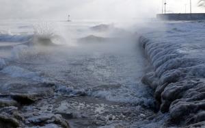
Ice forms as waves crash along Lake Michigan in below-normal temperatures near Oak Street Beach, Mon …
Mike Gillispie, a weather service meteorologist in Sioux Falls, South Dakota, said local road conditions "are going to be deteriorating very rapidly.
"If you don't have to be out and about, it's a good time to stay indoors," he said.
PLAN AHEAD FOR THE COLD
Officials in the coldest areas are urging residents to bundle up to guard against hypothermia and exercise caution while driving.
Grand Valley State University student Emny Deleon waits for a bus at the downtown campus, Monday, Ja …
In Detroit and across Illinois, warming centers have opened to provide temporary relief from the cold.
RELIEF IS IN SIGHT
Temperatures are expected to be lower than normal for days but could rise a bit by the end of the week.
"We have cold temperatures, but it's not like it never happened before," said Bob Oravec, a meteorologist with the Weather Prediction Center. "It's typical for an Arctic outbreak."
___
Associated Press writers Sarah Rankin in Chicago and Blake Nicholson in Bismarck, North Dakota, contributed to this report.
No comments:
Post a Comment